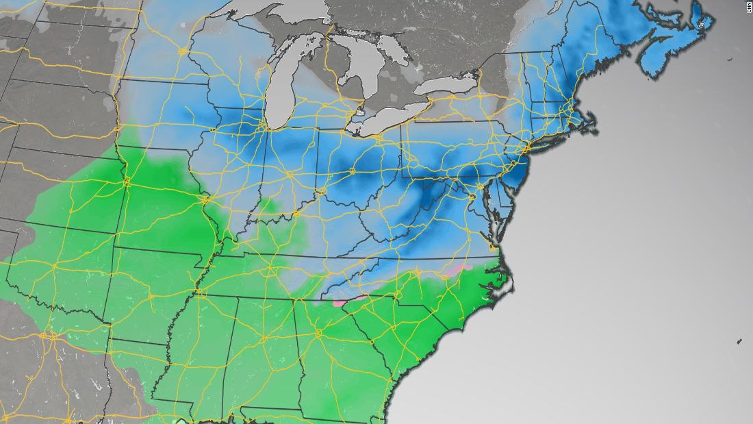
“Predicting the value of snowfall in the nation’s capital is rarely easy, but confidence is growing that the DC area will see significant snowfall on Sunday and will last until Monday,” said CNN meteorologist Taylor Ward.
A major winter storm is underway and could bring up to 25 centimeters of snow to the country’s capital. That would end the 708-day sequence that Washington, DC, went through without a snowfall greater than 1 inch.
“The only other time this happened was in a 788-day sequence that ended in 2013,” said CNN meteorologist Brandon Miller.
The storm’s trail
On Saturday, the storm system will bring heavy rain in the middle of the country. Salt Lake City can also see some prolonged blizzards on Saturday morning.
More distant areas to the east, such as St. Louis and Springfield, Illinois, will see another rain / snow mix on Sunday. The exact amount of snow that will stick to the ground remains uncertain.
A week after areas of Iowa were hit by snow, Hawkeye State was able to see a few more inches this weekend.
Winds will rise on Saturday across the Central Plains, which will increase fire threats in parts of Kansas, Oklahoma and Texas.
Much of the Mississippi River valley will receive heavy rain and parts of the Midwest will have snow. Chicago is on a winter storm alert on Sunday morning, with 5 to 9 inches of snow possible. Along with the snow, 30 mph winds are expected across the region, which can result in dangerous travel conditions.
The best chance for heavy snow seems to include areas in northern Illinois, Indiana and Ohio, as well as southern Wisconsin.
The storm will continue in the east, pouring rain in the southeast and snow in the Ohio Valley before heading east and creating a concern about ice in parts of North Carolina, Virginia and West Virginia.
A developing Nor’easter
“The snow will move from the southwest to the northeast on Saturday night and early Sunday morning, with snow likely to be spreading mid-Sunday morning,” said the weather service office in Baltimore and Washington, DC.
From Sunday afternoon to Monday, there is the possibility of a change to hail and freezing rain.
With the storm system for several days, there is still some uncertainty in forecasting how much snow will fall in the Northeast.
“There seems to be a consensus among the forecast models that moderate to heavy snow will occur from parts of Virginia to Pennsylvania and New Jersey, but there remains some uncertainty about the exact path of low pressure Monday through Tuesday,” said Ward . “This will have a significant impact on the amount of snow that falls from New York City to New England. A storm system parallel to the coast would provide greater snowfall, while a trail further east to the sea would limit the total snowfall. in New England. “
This can make a difference in places like Boston and New York with 10 centimeters of snow or 30 centimeters.
The Philadelphia weather services office is forecasting more than 15 centimeters of snow with gusts of up to 72 km / h, “creating a significant amount of blown snow”.
The Boston meteorological services office on Friday hinted at the storm and its possible effects.
The storm will then clear the coast on Tuesday.
Allison Chinchar of CNN contributed to this report.
